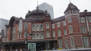
Below is a Map of Marunouchi with the major attractions numbered. You will note the huge Imperial Palace park in the centre of the map with the rail lines to the east of it. This is where Tokyo Station is and it is here where many visitors arrive to Tokyo on the Shinkansen bullet train. To the east of this map is the Ginza area while many government buildings are situated in the South West.
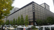
A Tokyo International Forum
B Imperial Palace
C Kitanomaru Garden
D Kokyogaien Garden
E Imperial Palace Grounds
F East Gardens
G Nippon Budokan
H Science Museum
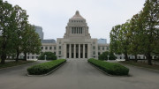
J Natiional Diet Building
Train Stations and services in area (Pins 1 to 5)
Tokyo Station (1)
JR East:
Chūō Main Line
Keihin-Tōhoku Line
Keiyō Line
Sōbu Main Line
Tōkaidō Main Line
Yamanote Line
Yokosuka Line
Tōhoku Shinkansen
Yamagata Shinkansen
Akita Shinkansen
Jōetsu Shinkansen
Nagano Shinkansen
JR Central:
Tōkaidō Shinkansen
Tokyo Metro:
Marunouchi Line
JR Yurakucho Station (2)
JR East:
Keihin-Tōhoku Line
Yamanote Line
Tokyo Metro:
Yūrakuchō Line
Otemachi Station (3)
Tokyo Metro:
Chiyoda Line
Hanzōmon Line
Marunouchi Line
Tōzai Line
Toei:
Mita Line
Sakuradamon Station (4)
Tokyo Metro:
Yūrakuchō Line
Takebashi Station (5)
Tokyo Metro:
Tōzai Line
Right click here and choose “save as” to download a kml file of the above map to use in google earth