Below is a Map of Akihabara with the major attractions numbered. You will note the huge Akihabara station in the center of the map, around this area is where many of the duty-free electronics shops are located and continue up Chuo Dori. Chuo Dori is closed to traffic on Sundays, and the whole area is filled with Japanese Otaku (Geeks). Laox’s Main store was once the largest electronics store in Japan until Yodabashi Camera opened a few years back on the other side of Akiba Station.
A Chuo Dori (Main shopping strip)
B Yodabashi Camera
C Used Electroincs Block
D Laox Electronics
E Yushima Seido Temple
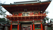
F Kanda Myojin Shrine
Train Stations and services in area (Pins 1 to 3)
Akihabara Station (1)
JR East:
Keihin-Tōhoku Line
Yamanote Line
Chūō-Sōbu Line
Tokyo Metro:
Hibiya Line
Metropolitan Intercity Railway Company:
Tsukuba Express
Ochanomizu Station (2)
JR-East:
Chūō-Sōbu Line
Chuo Line Rapid
Tokyo Metro:
Marunouchi Line
Iwamotochō Station (3)
Toei Subway:
Toei Shinjuku Line
Right click here and choose “save as” to download a kml file of the above map to use in Google Earth.